The Dungate property in its entirety is thought to be mostly underlain by volcanic rocks of either the Jurassic Hazleton Group or the Eocene Endako Group. These volcanic rocks have been intruded by a probable Quartz feldspar Porphyry (“QFP”) intrusion of Eocene age. The currently known mineralization on the property is proximal to the immediate area of this QFP intrusion.
This geological environment hosts potential for porphyry copper-gold-molybdenum mineralization. Outcrop on the property is limited but in the southeast quadrant of the IP anomaly (identified in 2020) potassic altered quartz feldspar porphyry intrusive occurs in historic trenches with sulphide mineralization grading up to 0.54% Cu, and up to 1.70 g/t Au in nearby outcrops.
Edgemont commenced exploration in 2018 with a brief program, collecting six rock samples and eight soil samples as part of a brief orientation to the property. The rock sampling confirmed the presence of copper-gold mineralization (Lefebure, Setterfield, 2019) on the Dungate Project. Highlights of the 2018 rock sampling are as follows:
In 2019, Edgemont contracted a ground magnetometer survey of Tenure 1057771. Walcott surveyed 84 line kilometres of north-south lines at 50 metre intervals with readings collected at one second intervals. The final data was then presented as a contoured plan map of TMI (Total Magnetic Intensity (nT)) and Calculated 1st Vertical Derivative of TMI (nT/m).
Edgemont subsequently conducted a property wide soil sample survey, geological mapping and prospecting. The three-man crew put in 31.2 line kilometres of soil line, collected 604 soil samples and 80 rock samples. Soil sampling concentrated over the inferred map area of the Quartz Feldspar Porphyry with lines spaced at 100 metres and samples collected at 50m intervals. Outside of the area mapped QFP, every second line was run northeast, to the claim boundary.
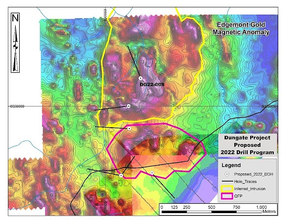
The 2019 program also featured geological mapping and prospecting. The mapped area of the QFP corresponds to a magnetic high in the 2019 survey. Other magnetic highs located north of this are un explained and hidden by overburden and are circled in yellow on the following map:
The 2019 soil sampling program identified copper and gold soil anomalies within (copper) and around (copper, gold) the inferred area of the QFP. Anomalies are along the eastern and southern boundaries of the map unit. Two correlated sets of results standout, copper-cadmium and gold-arsenic-bismuth-tellurium (Table 6).
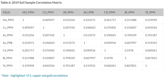
Examination of the data shows cadmium, bismuth and tellurium results are very close to the detection limits for these elements. Therefore their results are not plotted. Results for gold, copper and arsenic are plotted with results for gold contoured at 5ppb, copper 100ppm and arsenic at 10ppm. Gold forms discrete anomalous areas around the historical trenches and the eastern portion of the QFP. Copper anomalies are found within the QFP and along it’s southern margin. Arsenic shows a very broad zone along the southern and eastern portions of the QFP. These element correlations are consistent with those found in epithermal/mesothermal or a high level porphyry system.
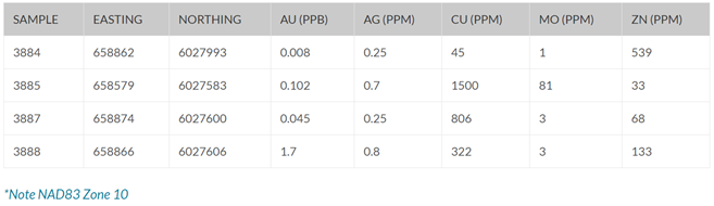
The highest 2019 rock copper value in rocks (sample 2596468) returned 5428.8ppm Cu and was collected from a rubble pile at the historical trench site. The rock was strongly oxidized, clay-sericite altered with most sulfides indiscernible due to oxidation. Traces of molybdenite and copper oxide were visible. The highest gold value (sample 2596455) returned 553.8ppb Au and came from QFP on a muck pile adjacent to a historical trench containing 20% quartz stockwork.
In September, sixteen line kilometers of cut line were established and an induced polarization (“IP”) survey completed in October. The IP response indicates a strong cohesive circular chargeable anomaly approximately 1,200 meters in diameter (chargeability response varies from 15mv/v to greater than 60 mv/v) that is coincident with a total magnetic high on the southern half of the anomaly where a magnetic survey was completed in 2019. The northern half of the chargeability anomaly has a coincident resistivity high. See figure 7 below.
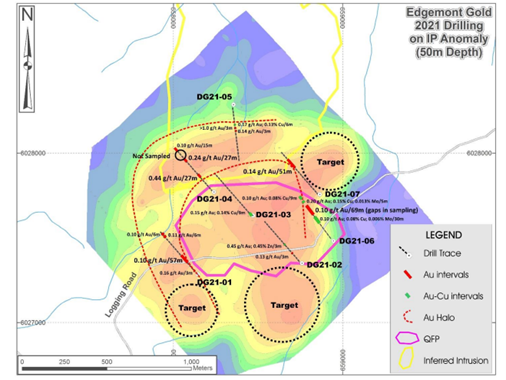
In the fall of 2021, a total of seven holes, totaling 3,427m, were drilled at Dungate. The target for this program was a coincident magnetic and IP anomaly of 1.2 kilometers diameter that was interpreted to be a quartz-feldspar porphyry (“QFP”) intrusion. QFP was intersected in six of the seven holes.
Drilling has confirmed that anomalous gold is widespread in a halo forming a shell along the edges of the QFP and into the contact host rocks. Highlights from this drilling include:
Gold Zones
Hole DG21-04: 27m @ 0.44 g/t Au (including 6m @ 1.27g/t Au)
and 27m @ 0.24 g/t Au (sampling ended in gold zone) and 15m @ 0.10 g/t Au (at bottom of hole)
Hole DG21-07: 51m @ 0.11 g/t Au
Hole DG21-06: 69m @ 0.10 g/t Au Hole DG21-01: 57m @ 0.10 g/t Au
Hole DG21-02: 3m @ 0.45 g/t Au, 0.45% Zn
Hole 2021-005: 6m @ 0.17 g/t Au and 0.13% Cu 3m @ >1.0 g/t Au
Copper – Molybdenum Zones
Hole 2021-002: 237m @ 0.06% Cu and 0.007% Mo
Hole 2021-003: 249m @ 0.07% Cu & 0.006% Mo (including 44m @ 0.09% Cu and 0.01% Mo)
The location of all holes drilled in 2021, with assay results indicated is provided on the following map:
Drill Locations and Gold Intersections – 2021 Drilling